Sunday, October 28, 2007

Tropical Storm Noel and Venus Square Jupiter


The Weather Alternative post Will the Atlantic Give Us Hurricane Noel or Olga? of October 17th mentioned the potential for tropical storm or hurricane formation around October 28th due to the Venus-Jupiter square. Noel began as tropical depression 16 at longitude 71 west and latitude 15 north or about 195 miles south-southeast of Port Au Prince Haiti late on October 27th.


The Weather Alternative pinpointed the eastern Atlantic as one place where storm formation might take place and also around 54 west longitude as another place. Although a tropical wave passed over 54 west between the 27th and 28th, the real winner, as we already know, was longitude 71 west/latitude 15 north.


When reviewing this season's solar ingress chart, it's obvious that that was the more potent geographical area since the Venus-Jupiter square was angular over that very place. The importance of the seasonal solar ingress chart has been brought out in other posts, but I failed to follow my own good advice, in this case by not noting where the Venus-Jupiter square was operating in that all-important chart.


Believe while others are doubting.
Plan while others are playing.
Study while others are sleeping.
Decide while others are delaying.
Prepare while others are daydreaming.
Begin while others are procrastinating.

Work while others are wishing.
Save while others are wasting.
Listen while others are talking.
Smile while others are frowning.
Commend while others are criticizing.
Persist while others are quitting.

Inspirational quotes by William Arthur Ward

Friday, October 26, 2007

More October 2007 Forecast Results


The Weather Alternative forecast for October 20-23 called for a tropical wave or tropical storm system to affect the island of Puerto Rico between these dates. The National Weather Service reported the following on Monday, October 22nd:

AN APPROACHING TROPICAL WAVE WILL BRING ADDITIONAL LOW LEVEL MOISTURE TO THE REGION ON TUESDAY (23rd) AND WEDNESDAY (24th)...RESULTING IN AN INCREASE IN THE AREAL COVERAGE AND INTENSITY OF SHOWERS OVER PUERTO RICO THE NEXT TWO AFTERNOONS. AS A RESULT...LOCALIZED FLOODING OF SMALL STREAMS AND URBAN AREAS CAN BE EXPECTED TUESDAY AND WEDNESDAY AFTERNOONS.

The forecast for the 21st through the 23rd called for a stormy period from Michigan southward to Florida with perhaps a tropical system developing in the eastern Gulf of Mexico. Although no tropical system developed, Accuweather reported that abundant moisture from the Gulf helped to create drenching thunderstorms over the southern states.

Accuweather October 21, 2007
Heavy Southern Storms Updated: Sunday, October 21, 2007 3:36 PM With rich moisture surging in from the Gulf of Mexico and a cold front approaching, the ingredients will be in place for drenching thunderstorms to impact a part of the South Monday into Monday night.

Between the 22nd and 24th The Weather Alternative called for a cold front to penetrate the Plains due to the Sun's conjunction to Mercury, and Venus' opposition to Uranus.


Here's Accuweather's report for the 22nd:
The storm system that produced snow in the central Rockies on Sunday will drive a strong cold front through the southern Plains today. Highs will be held in the 50s today around the Dallas-Fort Worth Metroplex, while Houston to San Antonio and Brownsville will also have a dramatic change from the summerlike heat. Temperatures today into Tuesday will be at the coolest levels since late spring throughout most of the Lone Star State.

The last Weather Alternative forecast to report called for a major storm system packing high winds and rain to hit the West Coast between October 23rd and the 26th. The devastating Santa Ana winds were already dealing a tragic blow to southern California at this time. Unfortunately, no rain accompanied the winds. The Pacific Northwest also experienced brisk winds as shown by the following National Weather Service Hazardous Weather Outlook for October 24th:

502 AM PDT WED OCT 24 2007
THIS HAZARDOUS WEATHER OUTLOOK IS FOR NORTHWEST OREGON AND SOUTHWEST WASHINGTON.
BRISK EAST WINDS ARE EXPECTED TO DEVELOP OVER MUCH OF THE AREA THURSDAY NIGHT (25th) AND FRIDAY (26th) AND CONTINUE THROUGH SATURDAY.
Recent Forecasts


The concept of natural selection was the basis of Darwinism. This assertion is stressed even in the title of the book in which Darwin proposed his theory: The Origin of Species, by means of Natural Selection…
Natural selection is based on the assumption that in nature there is a constant struggle for survival. It favors organisms with traits that best enable them to cope with pressures exerted by the environment. At the end of this struggle, the strongest ones, the ones most suited to natural conditions, survive. For example, in a herd of deer under threat from predators, those individuals that can run fastest will naturally survive. As a consequence, the herd of deer will eventually consist of only fast-running individuals.


However, no matter how long this process goes on, it will not transform those deer into another species. The weak deer are eliminated, the strong survive, but, since no alteration in their genetic data takes place, no transformation of a species occurs. Despite the continuous processes of selection, deer continue to exist as deer. - Harun Yahya

Tuesday, October 23, 2007

November 2007 Hurricane and Severe Weather Outlook

Here are a number of long-range weather forecasts for November 2007. The forecasts are based on planetary cycles.


Forecast
Nov 1-3
The National Weather Service will be posting Winter Storm Warnings at this time for the Pacific Northwest as a powerful low-pressure system cranks up off shore and heads inland. Mercury, often equated with strong winds and cold fronts, is one of the main players as it turns direct now after about a three week period of retrograde motion.
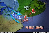
Forecast
Nov 1-3
A cold front triggers storms over the Northeast.

Forecast
Nov 1-3
Possible tropical storm or hurricane formation between 35 and 43 west and around 16 north at this time.

Forecast
Nov 5-6
The Last Quarter Moon phase focuses the explosive energies of the square between Venus and Pluto over the Plains. The storms will push toward the Mississippi Valley.

Forecast
Nov 5-7 and 9-12
Possible tropical storm or hurricane formation about 450 miles northeast of Puerto Rico in and around 63 west longitude and 24 north latitude based on the Venus-Pluto square. This is triggered once again between the 9th and 12th.

Forecast
Nov 5-8
Another storm system moves in to the Pacific Northwest. By the 8th, fair but colder conditions embrace the area.

Forecast
Nov 8-10
A windy low-pressure system affects the eastern Great Lakes and pushes through New England.

Forecast
Nov 8-11
Weather in the Plains remains active. The northern states in and around the Dakotas and Minnesota are the focal point for severe storms as the ingredients necessary to generate a strong atmospheric disturbance should be present in generous amounts.

Forecast
Nov 9-12
Changes are underway for the Rockies. The Sun affects the 105th meridian through the eastern Rockies as it forms aspects with Pluto and Neptune. The cold factor represented by Pluto and the warm and moist factors shown by Neptune should provide the necessary clashing of atmospheric conditions to produce a low-pressure system over the Rockies. Heavy precipitation is possible especially in and around Nevada.

Forecast
Nov 12-14
More cold air sweeps into the Northeast generating storms.

Forecast
Nov 14-19

Mars now begins its retrograde movement and is placed along 111 west longitude through the Rockies. At the beginning of this period, on the 14th and 15th, the Moon will give Mars a shove. Not a good thing to do to the warrior planet. Mars will most likely respond by turning up the heat. Whereas Mars usually corresponds to heat and dryness, since Mars is in the water sign Cancer, this may result in heat and humidity instead leading to storms.
The 16th through the 19th indicates a strong storm center generating a windy state of affairs over the northern Rockies. The forecast period ends with Venus squaring the now retrograde Mars with severe weather centering over the Colorado-New Mexico area.

Forecast
Nov 15-19
Mars' Retrograde station will turn up the heat and humidity over the Mid-Atlantic and Northeast, which may lead to stormy conditions there. Severe weather is indicated over the Bahamas now, perhaps of a tropical nature, which could be drawn northward towards North Carolina.

Forecast
Nov 16-19
The West Coast States will endure more rain and wind as a southerly air flow feeds moisture into a low-pressure system.

Forecast
Nov 16-19
Around the 16th storms invade the Plains region. At the end of the forecast period the disruptive energies of the Venus-Mars square converge on the central U.S. states of Kansas, Oklahoma, and Texas where dangerous storms are likely.

Forecast
Nov 16-19
A low-pressure system, probably located near Quebec, will affect the New England area

Forecast
Nov 21-22
The parade of wet weather for the West Coast continues as another storm system is ushered into the area.

Forecast
Nov 23-25
Another stormy period for the Rockies is shown this time by Mercury's square to Neptune, which has taken up residence over the Rockies during autumn.

Forecast
Nov 23-25

Cold Canadian air will make its way southward and ignite storms over the central U.S. Moisture from the Gulf is available now creating storms over the southern portions of Texas as it is drawn northward into the southern Plains.

Forecast
Nov 23-25
A storm system will plague the New England area.


Forecast
Nov 24-26
An intensifying storm will deliver its rainy message to the Mississippi Valley as well and push eastward. The Louisiana and Mississippi area are expected to receive a concentrated dose of wet weather.

Forecast
Nov 24-28
With Uranus' direct station on the 24th, and the Sun's first square to the most recent Lunar Eclipse inclement weather should hit the Northeast. Uranus is a cold and dry weather breeder and probably indicates a strong cold front, which will trigger noticeable
storms over the area.

Forecast
Nov 28 - Dec 2
This five day period starts off with cold air being ushered in over the West Coast due to Venus parallel Uranus perhaps resulting in precipitation. From the 30th on, Sun square Saturn brings a major storm system, which will not only affect the Pacific Northwest but also the southern portions of California and Nevada.


Forecast
Nov 28-Dec 2
The Sun's square to Saturn in the seasonal chart will upset atmospheric conditions over the eastern U.S. A storm system or a cold front triggering storms will push through the area. Potentially, weather could turn severe over the Ohio Valley.


The beautiful art work included in this post is by Charles L. Peterson


Dietary Wisdom

- People who diet go to great lengths to avoid great widths.
- Dieting is merely a matter of keeping your mouth shut at the right time--such as breakfast, lunch & dinner.
- The ideal diet is expressed in four words: "No more, thank you."
- Overweight doesn't happen overnight. It snacks up on you.
- He who indulges, bulges.
- Diets are for people who are "thick & tired" of it.
- When it comes to eating, you can sometimes help yourself more by helping yourself less.
- Eating slowly helps to keep one slim; in other words, haste makes waist.
- Under exercising rather than overeating may well be the more important cause of overweight today.


Saturday, October 20, 2007

Kiko and the West Coast

On September 22nd, The Weather Alternative posted the following forecast for October 18-22, 2007.

Forecast
Oct 18-20
Around this time tropical storm formation is possible in the eastern Pacific near 119 West, 21 North (about 620 miles west southwest of Cabo San Lucas). In addition, a front pushes in to the Pacific Northwest perhaps due to a low-pressure system off the California-Oregon coast.

Although Tropical Storm Kiko formed at this time, it began as tropical depression 15-E at 108 West, 14 North much to far away from 119 West, 21 North to consider it as a fulfillment of the forecast.

On the other hand, the Pacific Northwest was hit by a number of low-pressure systems as shown in the two Accuweather Maps for the 18th and 19th.

Accuweather October 18th
A major Pacific storm over the Northwest will bring heavy rain and strong winds to much of the region today. Coastal areas from Washington to northern California will get the worst of the storm as winds gusting in excess of 40 mph and heavy rain create a miserable day. A wintry mix will fall in the Washington Cascades, while showers will dampen the northern Rockies.

Accuweathe October 19th
Another storm will hit the Northwest Friday, dumping wet weather from the coast to Montana. During daytime, the northern California coast will be the hardest-hit by heavy rain. Elsewhere, gusty winds will impact Idaho and western Montana.

Some Forecasts For October 2007

October 2007 Hurricane and Severe Weather Outlook

One of the greatest ironies of the twentieth century is that many of the most deplorable acts of murder, intolerance and repression of the twentieth century were carried out by those who thought that religion was murderous, intolerant and repressive - and thus sought to remove it from the face of the planet as a humanitarian act. - Alister McGrath

Wednesday, October 17, 2007

Will the Atlantic Give Us Hurricane Noel or Olga?

During the second half of October and especially November the
average frequency of hurricanes sharply declines. Of course, hurricanes, and strong ones at that, are still possible. Back in August in a post entitled Switching on the Atlantic Hurricane Season with Solar Power, it was brought out how the Sun's transit to planets in the seasonal Solar Ingress chart would generate tropical activity in the central Atlantic. The time and place pinpointed in that article was later fulfilled in Hurricane Dean.

Does the Atlantic still have what it takes to give us Hurricanes Noel and Olga? A Venus-Jupiter square on the 28th of October has the potential to spark tropical storm or hurricane formation in the Atlantic. The Full Moon chart places this square in the eastern Atlantic around 29 west longitude and 16 north latitude. The Solar Ingress chart seems to promise storm formation near there as well--in and around 33 west longitude and 20 north latitude.

One other place stands out in the western Atlantic at this time around 54 west longitude and 22 north latitude. These places should be monitored for tropical storm and/or hurricane formation close to the October 28th window.

Some Forecasts For October 2007
October 2007 Hurricane and Severe Weather Outlook

"When you're faced with little daily choices, form the habit of making the right decisions-the honest, loving ones. Then when you're faced with a really tough decision, you'll make the right one as well."

Sunday, October 14, 2007

Recent Nor'easter Fulfills Long-range Forecast

The Weather Alternative's September 18th post explained how
the Venus-Saturn conjunction of October 13th would affect weather conditions over the Northeast U.S.


Forecast
October 12-14
The Venus-Saturn conjunction on the 13th falls in opposition to the degree of the August 28th lunar eclipse. Atmospheric conditions will deteriorate considerably over the Northeast U.S. as low-pressure is drawn to the area. By themselves, this planetary combo signifies heavy downfall and easterly winds. Additional planetary phenomena at this time add intense cold fronts and high winds to the mix, which suggest the possibility of a tropical system.


Results

From Accuweather

Northeast Storm Ramps Up Updated: Thursday, October 11, 2007 9:18 AM

From tonight into Friday, the low pressure center off the East Coast will continue to strengthen as it slides north along Interstate 95 into New England. A soaking rain will pour down on central and upstate New York, New England and the surrounding Canadian provinces as the storm pulls in rich moisture from the Atlantic Ocean. Meanwhile, cold, gusty winds on the backside of the low will put a chill in the air. Motorists should use caution as the combination of wet roads and fallen leaves could create slick driving conditions.


Other Long-range Forecast Results

The following forecast was posted on September 22nd:

Forecast

Oct 9-13

A cold front pushing into the southern Mississippi Valley will bring windy conditions to the area and possibly generate strong storms.


The Accuweather map of October 8th at left shows the awaited cold front pushing into the southern U.S reaching the Gulf Coast by Thursday the 11th of October.


The next Accuweather map shows windy conditions affecting the southern States.

The National Weather Service posted the following warning on October 11th:

...DRY AND BREEZY CONDITIONS ACROSS CENTRAL ALABAMA THIS AFTERNOON...


.DRY AIR IN A POST FRONTAL AIRMASS AND NORTHERLY WINDS WILL CREATE POTENTIALLY DANGEROUS BURNING CONDITIONS. AS TEMPERATURES WARM THROUGH THE DAY...STRONGER WINDS WILL MIX DOWN TO THE SURFACE. THE COMBINATION OF DRY CONDITIONS AND BREEZY NORTHERLY WINDS WILL CREATE A HIGH FIRE DANGER.

Forecast

Oct 11-14

Mercury's retrograde station usually increases windy conditions or triggers storms packing gusty winds. The seasonal chart places this influence over the Rockies. The Sun's trine to Neptune also influences the same area and may help to tame some of Mercury's influence.

The National Weather Service posted the following outlooks and warnings:

Oct 11, 2007

THIS HAZARDOUS WEATHER OUTLOOK IS FOR NORTHEAST AND NORTH CENTRAL COLORADO.

IT WILL BE QUITE WINDY ON THE PLAINS SATURDAY (13TH)...SEVERAL INCHES OF SNOW MAY BE POSSIBLE. THIS WILL BE DUE TO A VIGOROUS STORM THAT WILL CROSS THE STATE LATE SATURDAY AND SUNDAY(14th).

Oct 12, 2007

THIS HAZARDOUS WEATHER OUTLOOK IS FOR THE WESTERN TWO THIRDS OF UTAH AND SOUTHWEST WYOMING.

SOUTHWESTERLY WINDS WILL INCREASE TODAY AHEAD OF A PACIFIC SYSTEM.

October 13, 2007

Albuquerque NM

RED FLAG WARNING FOR AREAS ALONG AND EAST OF THE CENTRAL MOUNTAIN CHAIN...FOR STRONG WINDS AND LOW HUMIDITIES...

A STRONG STORM SYSTEM CENTERED OVER THE GREAT BASIN TODAY WILL BRING BREEZY TO WINDY CONDITIONS TO MUCH OF NORTHERN AND CENTRAL NEW MEXICO.

Some Forecasts For October 2007

October 2007 Hurricane and Severe Weather Outlook

Thankfulness

Reflect upon your present blessings, of which every man has plenty; not on your past misfortunes of which all men have some.--Charles Dickens


Seeds of discouragement will not grow in the thankful heart.--Anonymous


Wednesday, October 10, 2007

East and West Coast Storms October 8-12, 2007 Forecast Results


Long-range forecasts posted back in September called for the East Coast to succumb to stormy and windy conditions due to the passage of a strong cold front, and for a storm system to hit the West Coast. The forecasts pinpointed the dates between October 8th and 12th based on the Jupiter-Uranus square.


East Coast Forecast


October 8-10


The Jupiter-Uranus pair is triggered again on the 8th and 9th of October when the Moon and Sun join in the configuration. Storms and windy conditions due to the passage of a strong cold front are likely over the Northeast.


Results


The above Accuweather Map shows a strong cold front affecting the Northeast and the development of a coast storm. According to Accuweather "As a stronger shot of colder air invades the mid-Atlantic Thursday, an area of low pressure will strengthen off the coastline. The low, undergoing further intensification, will continue to trek northward up the New England coast Friday. The Northeast will have widespread showers Thursday with a steadier rain soaking upstate New York, New England and the St. Lawrence Valley of Canada Thursday night into Friday. On the west side of the low, strong winds will howl across the entire Northeast Friday."


West Coast Forecast

Oct 9-12

A number of charts localize the effects of the Jupiter-Uranus square over the western U.S. I think we can count on a storm system hitting the West Coast and pushing into the Rockies.

Results

Accuweather reported;

Northwest Storm Impact Updated: Tuesday, October 09, 2007 9:59 AM

...Low pressure approaching the coast will bring high winds of 30-50 mph and heavy rain. The area expected to be hit hardest will be the northern California coast to the northern Oregon coast. Much of the activity will remain west of the Cascades due to the disruptions they frequently cause to incoming storms. On the heels of this storm, another will move into the region on Thursday.

Southwest Setup Updated: Wednesday, October 10, 2007 7:21 AM

A low pressure system will move through the Pacific Northwest Wednesday, accompanied by showers. However, there is another low pressure system that will take a more southerly track Friday into the northern California region. The low will deliver rain along the coast with some showers farther inland. The position of the low will also bring an onshore flow to Southern California, resulting in widespread low clouds along the coast. Winds will turn gusty across the mountains and deserts.

Some Forecasts For October 2007

October 2007 Hurricane and Severe Weather Outlook

What happened to Manhattan?

In the "New World" published by Johan De Laet in 1625, he described Manhattan Island as follows:

The land is excellent and agreeable, full of noble forest trees and grape vines, and nothing is wanting but the labor and industry of man to render it one of the finest and most fruitful lands in that part of the world.

Sunday, October 07, 2007

Mars and the Full Moon Oct 5-7, 2007 Forecast Results


The following long-range weather forecast was based on the September 26th Full Moon. At the time of Full Moon, the Sun was over longitude 118 west while the Moon was exactly opposite the Sun at longitude 61 east. Mars squared this degree on October 5th prompting the forecast below.
Forecast
Oct 5-7
The Full Moon of September 26 left its mark over the Intermountain West and is now activated by Mars.Expect stormy conditions to hit the area.
From Accuweather:
Storm Brings Wild Winds Updated: Friday, October 05, 2007 7:58 AM A storm system in the northern Rockies has dropped snow in the Cascades, Bitterroots of Montana, and Sierra Nevada, while causing very windy conditions in some places. Some areas to the east of the Sierra had winds that gusted to more than 100 mph! As this disturbance moves into the Plains by Saturday, more strong winds will whisk through passes and peaks of the Intermountain West, as well as the central valley of California and the northern Plains.
The day is yours, and yours also the night; you established the sun and moon.
It was you who set all the boundaries of the earth; you made both summer and winter. - Psalm 74:16-17

Wednesday, October 03, 2007

Warm Instead of Cold October 1-3, 2007 Forecast Results


The anticipated cold front over the Northeast U.S. between October 1st and 3rd, as called for in the long-range weather forecast posted this past September 18th, failed to materialize. Instead unseasonably warm weather has had its grip on the area during the forecast period.
The forecast also called for windy conditions. The National Weather Service did post a warning for the region on October 2nd.
426 AM EDT TUE OCT 2 2007
...ROUGH CONDITIONS IN THE OCEAN INLETS THE NEXT SEVERAL DAYS...
HIGH PRESSURE OVER OUR REGION COMBINED WITH LOWER PRESSURE OVER THE BAHAMAS HAS CREATED A LARGE AREA OF EASTERLY WINDS OF 20 TO 25KT WINDS OVER THE OPEN WATERS OF THE ATLANTIC...SOUTH OF 40DEGREES NORTH LATITUDE. LONG PERIOD SOUTHEAST SWELLS ARE AFFECTING OUR REGION AND WILL CONTINUE TO DO SO FOR THE NEXT SEVERAL DAYS.THE SWELLS WILL GRADUALLY BUILD FROM AROUND 3 FEET TODAY TO AROUND5 FEET ON WEDNESDAY.
Ceasing negative imaging will always cause your energy to increase. - David Allen