Monday, December 31, 2007

Frigid Arctic Air Greets the New Year


From ancient times until the present, astro-meteorologists have
associated Saturn's influence with cold waves and falling temperatures. Yesterday's trine between the Sun and Saturn corresponds to the cold wave shown by the Accuweather map at left and the following comment by their meteorologists:


Bitter Cold Invades Plains Updated:

Monday, December 31, 2007 8:41 AM


Arctic air will plunge into the northern Plains today. Highs will be in the single digits across portions of North Dakota with no warmth expected in the short term. Strong high pressure over the northern Rockies will help pump this cold air deeper into the region on Tuesday, with single-digit highs as far south as central Iowa. The high temperature on New Year's Day in Fargo, N.D., will max out at 0 degrees. Cold temperatures will continue across the northern Plains on Wednesday before warmer air works back into the area on Thursday.


Unfortunately, The Weather Alternative long-range forecast for December 31-January 2 failed
to take the Sun's trine to Saturn into consideration and forecast Rising temperatures...for the Mississippi Valley, which result in storm potential over the area.


The astro-locality map at left shows the Sun's position at the moment of Sun trine Saturn on December 30th. Exactly over the area of the country where the cold front will pass.

Some Observations About January's Weather Patterns 2008

Introduction to the Weather Alternative

How Long-Range Forecasts Are Made


Famous Quotes about Saturn

"Saturn seems to have impressed the seal of melancholy on me from the beginning." - Marsilio Ficino


“The scientific theory I like best is that the rings of Saturn are composed entirely of lost airline luggage.” - Mark Russell

Thursday, December 27, 2007

The Recent Midwest Blizzard

On December 22nd and 23rd, blizzard conditions affected parts of the Plains and Upper Midwest. The Weather Alternative long-range forecast for December 22-26, 2007 pinpointed the area from northern Texas to the Mississippi Valley for severe weather, heavy precipitation, and whipping winds.


The long-range forecast, issued on December 3rd, read as follows:


Forecast

December 22-26, 2007
The First Quarter Moon chart promises severe weather over northern Texas around the 22nd and 23rd as Venus squares Neptune. Both of these planets activate a southerly wind flow and a falling barometer. Under the square aspect precipitation is usually heavy.


Results

The Accuweather graphic for December 22nd above shows a low-pressure system over northern Texas. The Weather Channel reported Gusty winds and a swath of snow from northern New Mexico to northwest Texas will streak out into Kansas to western and northern Missouri and into the Midwest during the afternoon and evening.


Forecast

December 22-26, 2007

The arrival of winter on the 22nd places a strong grouping of planets over the Mississippi Valley, which will be activated over the following days.
The Mercury opposition Mars aspect on the 22nd kicks off this segment and brings whipping winds. A Sun-Jupiter conjunction on the same day and the Sun-Mars opposition on the 24th are warm and dry influences, which may interact with a contrary air mass to trigger storms. The period ends with Mars opposition Jupiter on the 26th which is also a storm breeder.

Results


The Accuweather graphic for December 23rd at left shows whipping winds over the Mississippi Valley area behind the storm system that brought blizzard conditions to Oklahoma, Kansas, and portions of Minnesota, Wisconsin and the Upper Peninsula of Michigan.


The forecast also mentioned storms over the Mississippi Valley on the 26th, which are shown in the Accuweather map at left. The storms, according to Accuwether covered East Texas, Louisiana and parts of Mississippi and Alabama.

Another disturbance on the 26th also brought more snow to Michigan and Wisconsin.

Some Observations About January's Weather Patterns 2008

Introduction to the Weather Alternative

How Long-Range Forecasts Are Made

“They now have a 900 number for atheists. When you call, nobody answers and you get charged for the call.” - Unknown

Thursday, December 20, 2007

Some Observations About January's Weather Patterns 2008

Orthodox meteorologist will proclaim the onset of winter on December 22, 2007. They will, however, be unknowledgeable as to how the moment of the Sun's transit over the Tropic of Capricorn will affect the very forecasts they will make throughout the season except for their very basic understanding of how solar energy will be at a minimum in the Northern Hemisphere due to the earth's tilt.


The ancients had a different understanding. An astrological chart set for the beginning of each season at the corresponding solstice or equinox afforded them more than just a broad-spectrum look at the season in question. From the planetary positions and aspects contained in the chart they extracted a more detailed look at the quality of that particular spring, summer, fall, or winter. Would it be a dry season or a windy one? Would it be a mild or a harsh winter? When would certain weather phenomena take place?


These seasonal charts are set for the moment the Sun enters each of the cardinal signs of the zodiac. The Sun’s entrance into Aries marks the beginning of spring. Similarly, the Sun’s entrance into Cancer, Libra, and Capricorn denotes the beginning of summer, fall, and winter respectively. These Cardinal Solar Ingress charts are valid for the entire season they represent.


This winter, mainstream weather forecasters will not notice the angular positions of the Sun, Mercury, Mars, Jupiter, and Pluto over the Mississippi Valley. Nor will they perceive, Saturn, and Uranus ascending and descending over the western U.S. with the Moon occupying the Midheaven there as well.


All of these planets will leave their mark on the winter season. That is because planets that fall on the angles i.e. the Ascendant, Descendant, Midheaven, and IC of these Cardinal Solar Ingress charts have been observed to impress their individual and combined influences on the weather.

Following are some long-range forecasts for January 2008 based on the Solar Ingress Chart.


Forecast
January 3-5, 2008
Venus will begin to affect the western U.S. at this time. Its influence generally increases temperatures and moisture. Expect a southerly air flow to bring precipitation to the West Coast States of Washington, Oregon, Nevada, and California.


Forecast
January 5-7, 2008

The West Coast continues to remain unsettled as a stormy pattern persists over the area.


Forecast
January 5-7, 2008

The Rockies is under the influence of the Sun's sextile to Uranus. Cold, dry air pushes southward over the Rockies. If enough moisture is in place, storms may be triggered.


Forecast
January 6-8, 2008
Mercury and Uranus are considered cold planets in astrometeorology. The Sun's sextile to Uranus and its parallel to Mercury are the main influences at work over the Northeast U.S. These planetary aspects with the Sun argue a strong cold front with perhaps windy conditions over the region.


Forecast
January 11-14, 2008

Cold, dry air from the north will clash with a warm, moist air mass over the Rockies generating a good storm system over the area.


Forecast
January 18-20, 2008
The Venus-Mars opposition on the 19th will affect the central Plains states and Texas. Along with the combined effect of Mercury's parallel to Pluto, this should result in storms there.


Forecast
January 20-22, 2007
Jupiter's trine to Saturn brings a lower range of temperatures and fair conditions. These conditions should be observed from the East Central States through the Mid-Atlantic and Northeast as well as on the West Coast.


Forecast
January 23-27, 2008
The eastern Plains and the Mississippi Valley are the focal points for severe weather during this five-day stretch. As is the case in most severe weather scenarios, warm and cold air masses collide resulting in storms. The 26th and 27th seem to be the most intense days.


Forecast
January 29-Feb 2, 2008
Mars now begins its direct movement after more than three months of retrograde motion. Mars is equated with warmth and dryness. Its position over 99 west longitude affects southern Texas northward through the Great Plains where we should see an increase in temperatures and dry conditions.

While weather patterns seem, at times, to move incoherently across the earth’s surface, there is an underlying order that God has established. This orderliness is made apparent when weather patterns are compared to planetary aspects, and Ingress and lunation charts. The premise that planetary influence specifically aids in the creation of our weather is dismissed as utter foolishness by modern science. This may account for their present-day lack of any long-range forecast capability. It could be worth their while to investigate it though, as it wouldn’t be the first time that the foolishness of God proves to be wiser than men!

More December 2007 Forecasts

Introduction to the Weather Alternative

How Long-Range Forecasts Are Made

Sunday, December 16, 2007

Big Time Storms!

Thanks to indications in the New Moon chart of December 9th The Weather Alternative was able to pinpoint today's major storm centers about one month before hand. (How Long-Range Forecasts Are Made) The forecast posted on November 18, 2007
stated:


Forecast

December 15-17, 2007

December's New Moon promises storms and colder conditions to develop in and around the Tennessee and Alabama area due to Saturn's placement in this lunation. Farther west, the British Columbia coast and the Pacific Northwest should prepare for a strong winter storm to visit the area.


Results

As far as the storms in and around Tennessee and Alabama, the above Accuweather graphic for December 15th shows a monster low-pressure area over that very area. The storm brought beneficial rains to the drought-stricken Southeast and then moved over the Northeast where it is having an major impact.


This Accuweather graphic shows the storms headed into the Pacific Northwest. The Weather Channel reported:

A series of Pacific systems will continue to invade the West Coast over the next few days.
The first cold front will today and produce showers and gusty winds from western Washington to northwest California and mainly light to moderate snow from the Cascades inland to the northern Rockies.

Canada's Meteorological Service reported the following today:

A strong frontal system approaching Vancouver Island is producing strong southeasterly winds 60 to 80 km/h over western and eastern Vancouver Island..Greater Victoria..Southern Gulf Islands and Sunshine Coast and up to 90 km/h southeast winds over North Vancouver Island and Central Coast - coastal sections. Winds will diminish to 30 km/h and veer to the west as the front passes this afternoon.
The front will bring significant snowfall in the Whistler area. Snowfall amounts 15 to 25 cm are expected today through tonight.

Introduction to the Weather Alternative

Some December, 2007 Long-range Forecasts

More December 2007 Forecasts

Getting It "Less Wrong"

In science, it is basically impossible to indefinitely prove anything when using the scientific method because the process is never-ending. When a scientist has created a hypothesis based on a summary of their observations, or things that they have seen, heard, for example, they then try to uncover a new observation that supports there idea through an experiment. However, this idea cannot ever be completely proved true, so what scientists do is try to make the idea "less wrong", by adjusting their hypotheses and performing new experiments. Nothing is ever completely definite.

Thursday, December 13, 2007

December 10-13, 2007 Forecast Results

The Weather Alternative post of December 3rd mentioned how solar eclipse degrees can be triggered months or years later and time the arrival of weather patterns over certain areas.

The forecast in question read as follows:

December 10-13, 2007
The Jupiter-Pluto conjunction of December 11th will square the March 18th, 2007 solar eclipse degree. At the time of the eclipse, the Sun and Moon descended off the U.S. West Coast along 129 west longitude. This should generate a strong storm system that hits the West Coast.

Results
One West Coast area to feel the effects of the Jupiter-Pluto trigger to the solar eclipse was central and southern California.

URGENT - WEATHER MESSAGE
NATIONAL WEATHER SERVICE
LOS ANGELES/OXNARD CA
333 AM PST TUE DEC 11 2007

..GUSTY NORTH TO NORTHEAST WINDS WILL AFFECT MUCH OF LOS ANGELES AND VENTURA COUNTIES TODAY...

A FAST MOVING STORM SYSTEM DROPPING THROUGH CENTRAL CALIFORNIA EARLY THIS MORNING WILL PAST JUST TO THE EAST OF THE REGION LATER THIS MORNING. INCREASING NORTH TO NORTHEAST FLOW ALOFT AND OFF SHORE SURFACE PRESSURE GRADIENTS WILL CAUSE GUSTY NORTH TO NORTHEAST WINDS TO DEVELOP IN THE MOUNTAINS OF LOS ANGELES AND VENTURA COUNTIES...AS WELL AS THE SANTA CLARITA VALLEY EARLY THIS MORNING.

As the above Accuweather map shows the coast of British Colombia and some of Washington State felt its impact.

The Meteorological Service of Canada reported the following:

Warnings
Central Coast - coastal sections
4:35 AM PST Tuesday 11 December 2007
Wind warning for Central Coast - coastal sections continued

Southeast winds up to 100 km/h for this morning.

A frontal system just west of the bc coast will move across the regions today and overnight. Ahead of the system very strong southeasterly winds are expected over the north coast this morning. Snow at times heavy is expected to spread along the coast with up to 10 cm in the south and 35 cm over the north coast.

Similar warnings were posted on December 12th as well.

Introduction to the Weather Alternative

How Long-Range Forecasts Are Made

Some December, 2007 Long-range Forecasts

More December 2007 Forecasts

Don't forget to check out Molly's site.

From Jesus, With Love
I know you, I see you, and I care about you. I care about each of your heartbreaks. I care about how you feel. I care about what you think. I care about the difficulties and hardships that you face. I care about your children. I care about your health. I care about your struggle for finances. I care about your material needs. I care about the things that you need for your children and the repairs that your vehicle needs. I care about your spiritual struggles. There is not one detail of your life that does not concern Me.

Monday, December 10, 2007

The Tropics Come Alive!

The tropics sprang to life yesterday as an area of low-pressure formed east of Puerto Rico. As has been shown numerous times on this blog, the seasonal Solar Ingress chart is an important key in "localizing" the effects of planetary aspects on the terrestrial sphere. The Solar Ingress chart is a chart set for the times the Sun enters the signs of Aries, Cancer, Libra, and Capricorn. In non-astrological terms, these are the moments of the beginnings of each of the four seasons: spring, summer, fall, and winter.


On December 11th, Jupiter will form an exact conjunction with Pluto. The transit Moon, however, triggers this conjunction itself today by conjoining Jupiter and Pluto.


The astro-locality map at left shows Jupiter, Pluto, and the Moon, represented by three yellow lines, converging over 62 west longitude.

The National Weather Service's report for today places the center of the low-pressure area approximately at 60 west longitude. The system is producing heavy squalls and gale force winds. Other factors in the ingress chart point to the latitude of the low-pressure area around 19 north.

Some December, 2007 Long-range Forecasts

More December 2007 Forecasts

"Stop and reflect on one of nature's small but intricate beauties-a flower perhaps, or a butterfly or a bird. If God cared enough to perfect each feature of these creations of His, surely He cares for you, too."


Friday, December 07, 2007

Coming Winter Storm

The winter storm that was referred to in The Weather
Alternative post of November 18, 2007 has, only over the last few days, become apparent to conventional meteorologists. Using planetary alignments enables astrometeorologists to make weather predictions far beyond the time frames that limit conventional forecasters.

The Weather Alternative's forecast calls for the storm to hit the Plains, and Texas, and to move through the eastern U.S. between December 6-10 causing travel problems. Accuweather is confirming today that travel problems will be very likely east of the Rockies. The above map shows the storm's path will confirm The Weather Alternative forecast.

Some December, 2007 Long-range Forecasts

More December 2007 Forecasts

At Christmas
By
Edgar A. Guest

A man is at his finest towards the finish of the year;
He is almost what he should be when the Christmas season’s here;
Then he’s thinking more of others than he’s thought the months before,
And the laughter of his children is a joy worth toiling for.
He is less a selfish creature than at any other time;
When the Christmas spirit rules him he comes close to the sublime.
When it’s Christmas man is bigger and is better in his part;
He is keener for the service that is prompted by the heart.

All the petty thoughts and narrow seem to vanish for a while,
And the true reward he’s seeking is the glory of a smile.
Then for others he is toiling and somehow it seems to me
That at Christmas he is almost what God wanted him to be.
If I had to paint a picture of a man I think I’d wait
Till he’d fought his selfish battles and had put aside his hate.
I’d not catch him at his labors when his thoughts are all of wealth,
On the long days and the dreary when he’s striving for himself.

I’d not take him when he’s sneering, when he’s scornful or depressed,
But I’d look for him at Christmas when he’s shining at his best.
Man is ever in a struggle and he’s oft misunderstood;
There are days the worst that’s in him is the master of the good.

But at Christmas kindness rules him and he puts himself aside,
And his petty hates are vanquished and his heart is opened wide.
Oh, I don’t know how to say it, but somehow it seems to me
That at Christmas man is almost what God sent him here to be.

Monday, December 03, 2007

More December 2007 Forecasts

The 20th Century's most renowned astrometeorologist, G.J. McCormack, said "It has been demonstrated by exhaustive observations and voluminous statistical data that transits of superior planets to the conjunction, opposition, or 90 degree angles to the degree of eclipse points are the true indicators and timing factors of effects.


December 10-13, 2007


The Jupiter-Pluto conjunction of December 11th will square the March 18th, 2007 solar eclipse degree. At the time of the eclipse, the Sun and Moon descended off the U.S. West Coast along 129 west longitude. This should generate a strong storm system that hits the West Coast.


December 22-26, 2007


The First Quarter Moon chart promises severe weather over northern Texas around the 22nd and 23rd as Venus squares Neptune. Both of these planets activate a southerly wind flow and a falling barometer. Under the square aspect precipitation is usually heavy.

The arrival of winter on the 22nd places a strong grouping of planets over the Mississippi Valley, which will be activated over the following days.

The Mercury opposition Mars aspect on the 22nd kicks off this segment and brings whipping winds. A Sun-Jupiter conjunction on the same day and the Sun-Mars opposition on the 24th are warm and dry influences, which may interact with a contrary air mass to trigger storms. The period ends with Mars opposition Jupiter on the 26th which is also a storm breeder.

December 31, 2007 - January 2, 2008

Rising temperatures are shown for the Mississippi Valley, which result in storm potential over the area.

Some December, 2007 Long-range Forecasts

Knowledge leads to reticence and modesty. The wise are the silent, the thoughtful are cautious of words and weary of conclusions. The really learned man is never the dogmatist. The more one knows, the more he realizes the unknown. the more one learns, the more there is which he knows he does not know. Ignorance is the mother of egotism. The less one knows, the more fuss he makes about it.

Friday, November 30, 2007

The Fun Begins Out West

Orthodox weather forecasters are wondering why so much energy is available for storms right now as a big one is cranking up in the
Southwest and soon to traverse the whole country. Astrometeorologists, or those that use planetary positions and cycles to create long-range weather forecasts, know that the answer is the Sun-Saturn square.


The Weather Alternative forecast for November 28th-December 2nd was posted on October 23rd. The forecast specified "that Sun square Saturn brings a major storm system, which will not only affect the Pacific Northwest but also the southern portions of California and Nevada."


Both of these particulars are being fulfilled now--a little over a month later. The forecast in itself is an impossibility for conventional forecasters whose forecast range at the most is 3 or 4 days. The Weather Channel map above shows the storm affecting southern portions of California and Nevada.


The Accuweather map at left shows the fulfillment of the other portion of the forecast as a storm hits the Pacific Northwest. More powerful storms will blast into the Pacific Northwest on Sunday (Dec 1) and Monday (Dec 2) with heavy rain, mountain snow, and powerful winds.


The storm in the Southwest will head east over the next few days and create lake-effect blizzards over the Great Lakes. New York, Ohio, and Pennsylvania are in the paths of this monster storm, which will probably fulfill the other long-range forecast for November 28-Dec 2 posted on The Weather Alternative that stated The Sun's square to Saturn in the seasonal chart will upset atmospheric conditions over the eastern U.S. A storm system or a cold front triggering storms will push through the area. Potentially, weather could turn severe over the Ohio Valley.

November 2007 Hurricane and Severe Weather Outlook

Some December, 2007 Long-range Forecasts

Faith of Our Fathers

On the 10th of May, 1774, news of the Port Bill reached Boston. The Port Bill stated that the harbor of the city would be closed to all shipping on June first if the citizens did not pay for the tea destroyed by the "wild Indians" of the Boston Tea Party.

When the news of this reached the House of Burgesses in Williamsburg, Virgina the members of the House declared the following:

House of Burgesses May 24, 1774

This House, being deeply impressed with apprehension of the great dangers to be derived to British America from the hostile invasion of the City of Boston in our sister colony of Massachusetts Bay, whose commerce and harbor are, on the first day of June next, to be stopped by an armed force, deem it highly necessary that the said first day of June be set apart, by the members of this House as a day of fasting, humiliation, and prayer, devoutly to implore the divine interposition for averting the heavy calamity which threatens destruction to our civil rights, and the evils of civil war; to give us one heart and one mind firmly to oppose, by all just and proper means, every injury to American rights...

Wednesday, November 28, 2007

Astro-Weather Twins: Jakarta and Northeast U.S.

November 27, 2007 BBC News

Several days of torrential rain have caused rivers to burst their banks, sending muddy water up to 3m (10ft) deep into homes and businesses.
Hundreds of residents are still holding out on the second floor of their homes, either trapped or unwilling to move, the BBC's Rebecca Henschke in Jakarta says.


The same astrological factors that brought wind and soaking rain to the Northeast U.S. affected the Jakarta area with torrential downpours. Due to other topographical features of the Southeast Asian city, this caused serious flooding.

In the Solar Ingress for the Fall season, Uranus occupied the 7th house cusp over the Northeast U.S. when it turned direct on November 24th. In Jakarta, the Solar Ingress places Uranus on the 1st house cusp.

The New Moon chart of November 9th placed Neptune, the pluvial planet par excellence, on the Midheaven through the Northeast U.S. and on the nadir through Jakarta. Mercury squared Neptune on the 24th.

The most recent lunar eclipse was triggered by the Sun's first square on the 27th. The Sun and Moon were rising and setting over Indonesia and the eastern U.S. at the time of the eclipse.

November 2007 Hurricane and Severe Weather Outlook

Some December, 2007 Long-range Forecasts

MORE COMMUNICATION KEYS FOR YOUR MARRIAGE--By H. Norman Wright

YOUR INNER CONVERSATIONS
Each of us carries on conversations with ourselves daily. This doesn't mean that we are odd or on the verge of spacing out. It's normal to talk to oneself. After you read this, however, I hope you will be much more conscious of your self talk. You will probably be shocked by the amount of time you spend on inner conversations & how those conversations affect your marriage.

Are you aware that:
--Most of your emotions--such as anger, depression, guilt, worry--are initiated & escalated by your self talk?
--The way you behave toward your spouse is often determined by your self talk & not by his or her behaviour?
--What you say & how you say it is a direct expression of your self talk?

Self talk is the message you tell yourself about yourself, your spouse, your experiences, the past, the future, God etc. It is a set of evaluating thoughts about facts & events that happen to you. As events are repeated, many of your thoughts, & thus your emotional responses, become almost automatic. Sometimes the words you tell yourself are never put together in clear statements. They may be more like impressions.

Monday, November 26, 2007

Rain and Wind for the Northeast

We're just a few days past Uranus' direct station and the cold
weather breeding planet is living up to its reputation. The Weather Alternative forecast for November 24-28, 2007 stated that Uranus' direct station and the Sun's first square to the most recent lunar eclipse would bring a strong cold front and noticeable storms over the Northeast U.S.


The Weather Channel graphic at the right shows the low-pressure system creating a stormy and rainy night in the Northeast. Weather forecasters reported that the storm is bringing soaking rains to much of the Northeast, some lake-effect snows near the Great Lakes, as well as a wintry mix to Upstate New York and parts of New England.


That's not all. As shown in the accompanying Accuweather map, behind the storm, the Great Lakes and Northeast will see increasing west to northwest winds gusting up to 40 mph.


In an earlier long-range forecast for November 23-25, 2007, The Weather Alternative called for a storm system to plague the New England area.

The storm hit a day earlier (22nd) than forecast and then ushered in cold air on strong, northwesterly winds on the 23rd as seen in the maps below.


November 2007 Hurricane and Severe Weather Outlook

Some December, 2007 Long-range Forecasts

Discover the force of the heavens O Men: once recognised it can be put to use. Johannes Kepler Discoverer of the planetary laws of motion and Astrometeorologist

Friday, November 23, 2007

Three Forecasts and a Storm

Mercury's square to Neptune, exact on November 24th, was the
basis for three long-range forecasts posted on The Weather Alternative at the end of October.


The first forecast called for a stormy period over the Rockies. The Accuweather map at right shows the storms over that area. The Weather Channel reported tonight that " ...snow is on the increase from Colorado and western Kansas to the southeast Arizona mountains, New Mexico and western Texas. The southern Rockies from the San Juan to the Sangre de Cristo and the Davis Mountains of southwest Texas could locally receive over a foot of snow...


The second forecast stated Cold Canadian air will make its way southward and ignite storms over the central U.S. Moisture from the Gulf is available now creating storms over the southern portions of Texas as it is drawn northward into the southern Plains.


The Accuweather map at left shows the storm that will develop over the southern portions of Texas through Saturday the 24th. They expect drenching rains to accompany this storm system.


The third forecast for the period between November 24th and 26th
warned that An intensifying storm will deliver its rainy message to the Mississippi Valley as well and push eastward. The Louisiana and Mississippi area are expected to receive a concentrated dose of wet weather.

Accuweather foresees "locally damaging thunderstorms are possible over the lower Mississippi Valley Sunday (25th) into Monday (26th)."

The Weather Channel predicts " The heaviest rain over eastern Texas and Louisiana Saturday could locally drop 1 to 3 inches." The Accuweather map at right shows the approaching storm over the area forecast in The Weather Alternative forecast last October.

November 2007 Hurricane and Severe Weather Outlook

Some December, 2007 Long-range Forecasts

A physician without a knowledge of Astrology has no right to call himself a physician. Hippocrates The Father of Modern Medicine

Tuesday, November 20, 2007

Here Comes the Cold!

An arctic air mass is headed southward over the Rockies and Plains
and will dump 2 to 4 inches of snow over Denver, Colorado starting tonight. The Weather Alternative in its long-range forecast for November 14-19, 2007 called for severe weather over the Colorado/New Mexico area--just a bit too early.


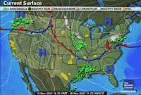
The same forecast called for "a strong storm system to generate a windy state of affairs over the northern Rockies." The Weather Channel map at left for the 18th shows a low-pressure area north of Montana. The National Weather Service reported the following:


URGENT - WEATHER MESSAGE NATIONAL WEATHER SERVICE GREAT FALLS MT318 AM MST SAT NOV 17 2007


...HIGH WIND WATCH REMAINS IN EFFECT FROM THIS EVENING THROUGH SUNDAY AFTERNOON...


November 18:


SUSTAINED WINDS OF 25 TO 40 MPH...WITH GUSTS UP TO 60 MPH...WILL CONTINUE IN THE WARNED AREA INTO EARLY SUNDAY AFTERNOON. AT 9 AM CUT BANK REPORTED A GUST TO 56 MPH AT THE AIRPORT.


Forecast November 15-19, 2007


The forecast for this period mentioned a possible tropical system over the Bahamas that perhaps would travel northward.


Results


Except for a low-pressure system on the 16th, no tropical system emerged.


The National Weather Service Nov 16


A SURFACE TROUGH IS ALONG 32N67 W26N70W TO THE BAHAMAS NEAR 22N74W. THIS SURFACE TROUGH IS WHAT REMAINS OF THE 1009 MB LOW PRESSURE CENTER..


Forecast November 16-19, 2007


The West Coast States will endure more rain and wind as a southerly air flow feeds moisture into a low-pressure system.

Results


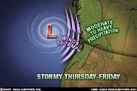
Accuweather confirmed the forecast with the following map and comment:

Northwest Train of Storms Updated: Thursday, November 15, 2007 10:09 AM The freight train of storms has started in the Northwest. A cold front in the region is the first of a series that will enter the region over the next few days. This system will produce rain and showers across the region, along with high winds that will make for a miserable day Thursday. Some areas of the Washington Cascades and northern Rockies will also receive freezing rain from these storms.

More Soaking Rain Updated: Sunday, November 18, 2007 8:04 AM A train of moisture building into the Northwest will bring rain and showers from the coast to Montana today. The heaviest of this moisture will be aimed at Oregon.

Forecast November 16-19, 2007

The last forecast called for dangerous storms over Kansas, Oklahoma, and Texas due to the disruptive energies of the Venus-Mars square. The Venus-Mars square is exact today (19th) and a larger window would have been more appropriate for the forecast for it is just tonight that the main weather event is shaping up. The National Weather Service reports the following for Texas, Kansas, and Oklahoma:

342 PM CST TUE NOV 20 2007

...MUCH COLDER AIR TO MOVE INTO THE REGION TONIGHT WITH A CHANCE FOR ACCUMULATING WINTER PRECIPITATION THURSDAY INTO SATURDAY...A STRONG COLD FRONT LOCATED OVER THE NORTHERN TEXAS PANHANDLE THIS AFTERNOON WILL CONTINUE MOVING SOUTH ACROSS THE SOUTH PLAINS DURING THE NIGHT. IT WILL BRING THE COLDEST TEMPERATURES OF THIS FALL SEASON.

DISCUSSION...A STRONG COLD FRONT MOVING SOUTHEAST THROUGH KANSAS THIS AFTERNOON WILL ENTER NORTHEAST OKLAHOMA EARLY TONIGHT AND MOVE TO THE SOUTHEAST CORNER OF OKLAHOMA BEFORE NOON ON WEDNESDAY. VERY STRONG SOUTH WINDS AHEAD OF THE FRONT WILL SHIFT NORTHWARD BEHIND THE FRONT.

November 2007 Hurricane and Severe Weather Outlook

Some December, 2007 Long-range Forecasts

Becoming Sensible About Failure


We learn very little by success. Success tends to make us comfortable & complacent. A reversal on the old saying would be "Nothing fails like success."

In 1927, Babe Ruth hit sixty home runs, more than anyone in the history of baseball. He also set another record that year: He struck out more than anyone in the history of baseball. The truth is, if you want to hit home runs, you must be willing to strike out. There is no way around this simple lesson of life. If you want your children to experience the exhilaration of success, then you must encourage them to learn how to fail--& in fact, to fail a lot.

It is this insight about failure that leads virtually all great innovators to pursue their work with a kind of obsession. Thomas Edison, who dabbled in the unknown almost all his life, was inspired to say, "Show me a thoroughly satisfied man & I will show you a failure."

The successful person is not one who never fails; instead, he is a person who dusts himself off after falling, & learns what obstacles to avoid in the road. The person who shuns failure will lie in the road & whine or, even worse, stay off the road in the first place, content to take a safe, well-known course throughout life, avoiding failure & personal fulfillment at the same time.

When a reporter asked Thomas Edison how it felt to have failed 25,000 times in his effort to create a simple storage battery, his reply was, "I don't know why you are calling it a failure. Today I know 25,000 ways not to make a battery. What do you know?"

If we train our children to go after achievement & ignore inner satisfaction, then we are teaching them to take the easy path, to be more concerned about the opinions & rewards bestowed upon us by others, & consequently to avoid any hint of failing. William Jones, the psychologist & philosopher, said, "The exclusive worship of success is our national disease."


By Dr. Wayne W. Dyer

Sunday, November 18, 2007

Some December, 2007 Long-range Forecasts

Forecast
December 6-10, 2007
Mercury's square to Saturn on December 6th will be followed by the Sun's square to Uranus on the the 7th. The all-important solar ingress map for the season places these over the East Central States and the Northeast. The New Moon chart localizes the Jupiter-Pluto conjunction (exact on the 11th) over the Northeast as well. All of these planetary aspects are heavy hitters when it comes to weather. The transit Moon will activate the Jupiter-Pluto conjunction on the 10th. A major storm system will plow through the eastern U.S. at this time and continue through the Northeast. Travel conditions will most likely be dangerous. Attention should be paid to local weather services for details regarding this storm.


Forecast
December 7-9, 2007
Perhaps related to the aforementioned weather system, planetary influences over the country's midsection show an invasion of cold air and windy conditions over Iowa, Missouri, Kansas, and Nebraska. This may be due to a low-pressure system that tracks through the area. Severe storms and colder conditions are also anticipated over the south central Texas area.


Forecast
December 15-17, 2007
December's New Moon promises storms and colder conditions to develop in and around the Tennessee and Alabama area due to Saturn's placement in this lunation. Farther west, the British Columbia coast and the Pacific Northwest should prepare for a strong winter storm to visit the area.

November 2007 Hurricane and Severe Weather Outlook


ATLANTA — Georgia Gov. Sonny Perdue stepped up to a podium outside the state Capitol on Tuesday and led a solemn crowd of several hundred people in a prayer for rain on his drought-stricken state."We've come together here simply for one reason and one reason only: To very reverently and respectfully pray up a storm," Perdue said after a choir provided a hymn.


Georgia and its neighboring states are caught in a drought that threatens public water supplies. Perdue has ordered water restrictions, launched a legal battle against the release of water from federal reservoirs and appealed to President Bush.
"It's time to appeal to him who can and will make a difference," Perdue told the crowd.


God bless him for having the conviction to do this.


Addendum Nov 20, 2007


Perhaps the Lord is beginning to answer their prayers. Today Accuweather posted the following map and comment.


Mother Nature will give the South something to be thankful for this Thanksgiving. A cold front will spread showers and thunderstorms over the drought-stricken region Wednesday into Thursday with noticeably cooler air to follow before a more widespread rain could reach the region late in the weekend.

It's a shame they can't say God is doing it. Today, as I was reading about the Pilgrims and the first Thanksgiving, I came across this bit of information. Three years after the Pilgrims celebrated Thanksgiving, they experienced a drought.

The 3rd year brought a spring and summer that was hot and dry with the crops dying in the fields. Governor Bradford ordered a day of fasting and prayer, and it was soon thereafter that the rain came.


http://www.holidays.net/thanksgiving/pilgrims.htm

Thursday, November 15, 2007

Stormy Northeast and Canada

Snow showers will spread into the Northeast interior by Friday, while a snow storm could develop over northern Maine. The rapidly developing storm will hit eastern Quebec and Atlantic Canada pretty hard. The Weather Alternative forecast posted on Ocotber 23rd indicated that between November 14th and 19th Mars' retrogade movement carried the potential to generate stormy conditions over the Mid-Atlantic and Northeast. The Weather Alternative also posted the following for November 16-19: A low-pressure system, probably located near Quebec, will affect the New England area.


The Meteorological Service of Canada today posted numerous weather warnings for eastern Canada similar to the following:

A low pressure system over new-hampshire is moving northeastward while intensifying and will lie over Sept-Îles Friday evening.This system will affect mostly central and eastern Québec today and Friday.
Regions west of the track of the low pressure system will receive significant snowfall amounts...


Forecast and results for November 8-11
The Accuweather graphic at the left for November 11th, coincides with The Weather Alternative forecast for November 8-11. The forecast called for active weather over the Plains states centering in and around the Dakotas and Minnesota. Here we see a low pressure system close to the forecast area.


Forecast and results for November 9-12


This forecast called for low-pressure over the Rockies with heavy precipitation over Nevada. The accompanying Accuweather map is for the 11th. They reported: Many areas from Southern California to Montana will experience rain or showers as this front progresses towards the southeast.


A front moving through Southern California on Sunday (11th) brought rain to the state and snow in Nevada, with 5.5 inches of snow reported near Wildhorse, Nev.


Forecast and results for Nov 12-14


This forecast called for cold air to sweep into the Northeast generating storms. The map at left is for the 14th. Accuweather reported:

A cold front passing through tonight (14th) and Thursday will quickly sweep out that mild air, causing rain to fall. Today's comfortable air will be replaced by a wintry blast, complete with noticeably cooler air, gusty and chilly winds and snow showers across the interior.

I am unable to post the results of the some of the forecasts from November 5-12 since I was out of the country and had no Internet service available.
November 2007 Hurricane and Severe Weather Outlook

At the end of World War II, it was General Omar Bradley, addressing an Armistice Day crowd, who said: “We have grasped the mystery of the atom and rejected the Sermon on the Mount. … The world has achieved brilliance without conscience. Ours is a world of nuclear giants and ethical infants.”
By Craige McMillan, WorldNetDaily


Sunday, November 04, 2007

A Rundown of Recent Forecasts


Here's a rundown on how recent long-range forecasts based on planetary cycles played out.


A powerful low-pressure system was forecast for the Pacific Northwest between Nov 1-3. The Accuweather map at right shows the arrival of a low on the 4th--a bit later than anticipated.

On the 3rd, Accuweather reported:

A cold front extending from an area of low pressure in Canada will bring a chilly rain to Washington and snow to parts of the Prairies in Canada. Cold air will spill down into the region behind the front as a result of an area of high pressure over British Columbia. This system will move eastward and strengthen to bring even colder air to the East coast.


November 1st through the 3rd was also to bring a cold front triggering storms over the Northeast U.S. The 3rd saw the arrival of Noel over the region with winds of 40 to 60 mph.


The Weather Alternative also called for possible tropical storm or hurricane formation between 35 and 43 west longitude. Between the 2nd and 3rd a tropical wave was reported over the above coordinates by the National Weather Service.

...TROPICAL WAVES...TROPICAL WAVE IS ALONG 33W S OF 16N MOVING W NEAR 10 KT. BROAD AREA OF SMALL CLUSTERS OF SCATTERED MODERATE/ISOLATED STRONG CONVECTION COVERS THE AREA FROM 3N-15N BETWEEN 30W-37W.

November 2007 Hurricane and Severe Weather Outlook

Typing monkeys don't write Shakespeare. (AP)

Give an infinite number of monkeys an infinite number of typewriters, the theory goes, and they will eventually produce the works of Shakespeare.

Give six monkeys one computer for a month, and they will make a mess. Researchers at Plymouth University in England reported that primates left alone with a computer attacked the machine and failed to produce a single word.

"They pressed a lot of S's," researcher Mike Phillips said. "Obviously, English isn't their first language."

At first, said Phillips, "the lead male got a stone and started bashing the hell out of the computer. Another thing they were interested in was in defecating and urinating all over the keyboard."

The notion that monkeys typing at random will eventually produce literature is often attributed to Thomas Huxley, a 19th-century scientist who supported Charles Darwin's theories of evolution.

Friday, November 02, 2007

Flooding in Southeast Mexico


A week of heavy rains caused rivers to overflow, leaving 70 percent of the Mexican State of Tabasco underwater as well as 80 percent of Villahermosa, the state capital. The state of Chiapas, which borders Tabasco to the south, also reported serious flooding, with officials there estimating that more than 100,000 people had been affected.


The Weather Alternative had posted a long-range weather forecast last September for the October 29th - November 2nd time period. The forecast warned of a possible low-pressure system to form off the east coast of Mexico around 96 west longitude and 23 north latitude. The flooding in Tabasco and Chiapas has taken place further south than those coordinates. The forecast was based on the Venus-Jupiter square of October 29th.


As can be seen from the astro-locality map, Venus and Jupiter were angular and formed a crossing off the east coast of Mexico accompanied by the Moon which had just squared Venus and opposed Jupiter. This is indicated on the map by the circle. The Tabasco-Chiapas area is shown by the square.

A glimpse at the astrological chart set for the Tabasco-Chiapas area shows that even there the planets held strong angular positions, and most likely account for the astrological influences at work behind the heavy rains and flooding. Our prayers are with the residents of the area and the government workers who are trying their best to help the victims.


Any fact facing us is not as important as our attitude toward it, for that determines our success or failure. The way you think about a fact may defeat you before you ever do anything about it. You are overcome by the fact because you think you are. - Norman Vincent Peale

Sunday, October 28, 2007

Tropical Storm Noel and Venus Square Jupiter


The Weather Alternative post Will the Atlantic Give Us Hurricane Noel or Olga? of October 17th mentioned the potential for tropical storm or hurricane formation around October 28th due to the Venus-Jupiter square. Noel began as tropical depression 16 at longitude 71 west and latitude 15 north or about 195 miles south-southeast of Port Au Prince Haiti late on October 27th.


The Weather Alternative pinpointed the eastern Atlantic as one place where storm formation might take place and also around 54 west longitude as another place. Although a tropical wave passed over 54 west between the 27th and 28th, the real winner, as we already know, was longitude 71 west/latitude 15 north.


When reviewing this season's solar ingress chart, it's obvious that that was the more potent geographical area since the Venus-Jupiter square was angular over that very place. The importance of the seasonal solar ingress chart has been brought out in other posts, but I failed to follow my own good advice, in this case by not noting where the Venus-Jupiter square was operating in that all-important chart.


Believe while others are doubting.
Plan while others are playing.
Study while others are sleeping.
Decide while others are delaying.
Prepare while others are daydreaming.
Begin while others are procrastinating.

Work while others are wishing.
Save while others are wasting.
Listen while others are talking.
Smile while others are frowning.
Commend while others are criticizing.
Persist while others are quitting.

Inspirational quotes by William Arthur Ward

Friday, October 26, 2007

More October 2007 Forecast Results


The Weather Alternative forecast for October 20-23 called for a tropical wave or tropical storm system to affect the island of Puerto Rico between these dates. The National Weather Service reported the following on Monday, October 22nd:

AN APPROACHING TROPICAL WAVE WILL BRING ADDITIONAL LOW LEVEL MOISTURE TO THE REGION ON TUESDAY (23rd) AND WEDNESDAY (24th)...RESULTING IN AN INCREASE IN THE AREAL COVERAGE AND INTENSITY OF SHOWERS OVER PUERTO RICO THE NEXT TWO AFTERNOONS. AS A RESULT...LOCALIZED FLOODING OF SMALL STREAMS AND URBAN AREAS CAN BE EXPECTED TUESDAY AND WEDNESDAY AFTERNOONS.

The forecast for the 21st through the 23rd called for a stormy period from Michigan southward to Florida with perhaps a tropical system developing in the eastern Gulf of Mexico. Although no tropical system developed, Accuweather reported that abundant moisture from the Gulf helped to create drenching thunderstorms over the southern states.

Accuweather October 21, 2007
Heavy Southern Storms Updated: Sunday, October 21, 2007 3:36 PM With rich moisture surging in from the Gulf of Mexico and a cold front approaching, the ingredients will be in place for drenching thunderstorms to impact a part of the South Monday into Monday night.

Between the 22nd and 24th The Weather Alternative called for a cold front to penetrate the Plains due to the Sun's conjunction to Mercury, and Venus' opposition to Uranus.


Here's Accuweather's report for the 22nd:
The storm system that produced snow in the central Rockies on Sunday will drive a strong cold front through the southern Plains today. Highs will be held in the 50s today around the Dallas-Fort Worth Metroplex, while Houston to San Antonio and Brownsville will also have a dramatic change from the summerlike heat. Temperatures today into Tuesday will be at the coolest levels since late spring throughout most of the Lone Star State.

The last Weather Alternative forecast to report called for a major storm system packing high winds and rain to hit the West Coast between October 23rd and the 26th. The devastating Santa Ana winds were already dealing a tragic blow to southern California at this time. Unfortunately, no rain accompanied the winds. The Pacific Northwest also experienced brisk winds as shown by the following National Weather Service Hazardous Weather Outlook for October 24th:

502 AM PDT WED OCT 24 2007
THIS HAZARDOUS WEATHER OUTLOOK IS FOR NORTHWEST OREGON AND SOUTHWEST WASHINGTON.
BRISK EAST WINDS ARE EXPECTED TO DEVELOP OVER MUCH OF THE AREA THURSDAY NIGHT (25th) AND FRIDAY (26th) AND CONTINUE THROUGH SATURDAY.
Recent Forecasts


The concept of natural selection was the basis of Darwinism. This assertion is stressed even in the title of the book in which Darwin proposed his theory: The Origin of Species, by means of Natural Selection…
Natural selection is based on the assumption that in nature there is a constant struggle for survival. It favors organisms with traits that best enable them to cope with pressures exerted by the environment. At the end of this struggle, the strongest ones, the ones most suited to natural conditions, survive. For example, in a herd of deer under threat from predators, those individuals that can run fastest will naturally survive. As a consequence, the herd of deer will eventually consist of only fast-running individuals.


However, no matter how long this process goes on, it will not transform those deer into another species. The weak deer are eliminated, the strong survive, but, since no alteration in their genetic data takes place, no transformation of a species occurs. Despite the continuous processes of selection, deer continue to exist as deer. - Harun Yahya

Tuesday, October 23, 2007

November 2007 Hurricane and Severe Weather Outlook

Here are a number of long-range weather forecasts for November 2007. The forecasts are based on planetary cycles.


Forecast
Nov 1-3
The National Weather Service will be posting Winter Storm Warnings at this time for the Pacific Northwest as a powerful low-pressure system cranks up off shore and heads inland. Mercury, often equated with strong winds and cold fronts, is one of the main players as it turns direct now after about a three week period of retrograde motion.

Forecast
Nov 1-3
A cold front triggers storms over the Northeast.

Forecast
Nov 1-3
Possible tropical storm or hurricane formation between 35 and 43 west and around 16 north at this time.

Forecast
Nov 5-6
The Last Quarter Moon phase focuses the explosive energies of the square between Venus and Pluto over the Plains. The storms will push toward the Mississippi Valley.

Forecast
Nov 5-7 and 9-12
Possible tropical storm or hurricane formation about 450 miles northeast of Puerto Rico in and around 63 west longitude and 24 north latitude based on the Venus-Pluto square. This is triggered once again between the 9th and 12th.

Forecast
Nov 5-8
Another storm system moves in to the Pacific Northwest. By the 8th, fair but colder conditions embrace the area.

Forecast
Nov 8-10
A windy low-pressure system affects the eastern Great Lakes and pushes through New England.

Forecast
Nov 8-11
Weather in the Plains remains active. The northern states in and around the Dakotas and Minnesota are the focal point for severe storms as the ingredients necessary to generate a strong atmospheric disturbance should be present in generous amounts.

Forecast
Nov 9-12
Changes are underway for the Rockies. The Sun affects the 105th meridian through the eastern Rockies as it forms aspects with Pluto and Neptune. The cold factor represented by Pluto and the warm and moist factors shown by Neptune should provide the necessary clashing of atmospheric conditions to produce a low-pressure system over the Rockies. Heavy precipitation is possible especially in and around Nevada.

Forecast
Nov 12-14
More cold air sweeps into the Northeast generating storms.

Forecast
Nov 14-19

Mars now begins its retrograde movement and is placed along 111 west longitude through the Rockies. At the beginning of this period, on the 14th and 15th, the Moon will give Mars a shove. Not a good thing to do to the warrior planet. Mars will most likely respond by turning up the heat. Whereas Mars usually corresponds to heat and dryness, since Mars is in the water sign Cancer, this may result in heat and humidity instead leading to storms.
The 16th through the 19th indicates a strong storm center generating a windy state of affairs over the northern Rockies. The forecast period ends with Venus squaring the now retrograde Mars with severe weather centering over the Colorado-New Mexico area.

Forecast
Nov 15-19
Mars' Retrograde station will turn up the heat and humidity over the Mid-Atlantic and Northeast, which may lead to stormy conditions there. Severe weather is indicated over the Bahamas now, perhaps of a tropical nature, which could be drawn northward towards North Carolina.

Forecast
Nov 16-19
The West Coast States will endure more rain and wind as a southerly air flow feeds moisture into a low-pressure system.

Forecast
Nov 16-19
Around the 16th storms invade the Plains region. At the end of the forecast period the disruptive energies of the Venus-Mars square converge on the central U.S. states of Kansas, Oklahoma, and Texas where dangerous storms are likely.

Forecast
Nov 16-19
A low-pressure system, probably located near Quebec, will affect the New England area

Forecast
Nov 21-22
The parade of wet weather for the West Coast continues as another storm system is ushered into the area.

Forecast
Nov 23-25
Another stormy period for the Rockies is shown this time by Mercury's square to Neptune, which has taken up residence over the Rockies during autumn.

Forecast
Nov 23-25

Cold Canadian air will make its way southward and ignite storms over the central U.S. Moisture from the Gulf is available now creating storms over the southern portions of Texas as it is drawn northward into the southern Plains.

Forecast
Nov 23-25
A storm system will plague the New England area.


Forecast
Nov 24-26
An intensifying storm will deliver its rainy message to the Mississippi Valley as well and push eastward. The Louisiana and Mississippi area are expected to receive a concentrated dose of wet weather.

Forecast
Nov 24-28
With Uranus' direct station on the 24th, and the Sun's first square to the most recent Lunar Eclipse inclement weather should hit the Northeast. Uranus is a cold and dry weather breeder and probably indicates a strong cold front, which will trigger noticeable
storms over the area.

Forecast
Nov 28 - Dec 2
This five day period starts off with cold air being ushered in over the West Coast due to Venus parallel Uranus perhaps resulting in precipitation. From the 30th on, Sun square Saturn brings a major storm system, which will not only affect the Pacific Northwest but also the southern portions of California and Nevada.


Forecast
Nov 28-Dec 2
The Sun's square to Saturn in the seasonal chart will upset atmospheric conditions over the eastern U.S. A storm system or a cold front triggering storms will push through the area. Potentially, weather could turn severe over the Ohio Valley.


The beautiful art work included in this post is by Charles L. Peterson


Dietary Wisdom

- People who diet go to great lengths to avoid great widths.
- Dieting is merely a matter of keeping your mouth shut at the right time--such as breakfast, lunch & dinner.
- The ideal diet is expressed in four words: "No more, thank you."
- Overweight doesn't happen overnight. It snacks up on you.
- He who indulges, bulges.
- Diets are for people who are "thick & tired" of it.
- When it comes to eating, you can sometimes help yourself more by helping yourself less.
- Eating slowly helps to keep one slim; in other words, haste makes waist.
- Under exercising rather than overeating may well be the more important cause of overweight today.